Ardmore
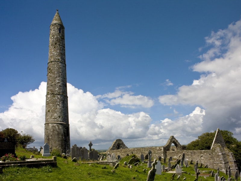
A pretty seaside village with a long sandy beach, Ardmore is Ireland’s oldest Christian settlement founded by St. Declan in 416 AD. Overlooking the village is the Round Tower, one of the best preserved in the county, standing over 97 feet high. The cliff walk at over 4km long is the deal place to view the beauty of the Waterford coastline. It is a perfect place for both young and old.
Ballymacarbry / Nire Valley – Location On Google Maps
This unspoilt area known as the Nire Valley offers you absolute peace and tranquillity, tucked away in the rugged Comeragh Mountains where time is unimportant. The Nire Valley is an ideal base for hill walkers who wish to explore the spectacular Comeragh Mountains. You may also prefer to see this beautiful scenery on horseback. Local Amenities: Accommodation – Bird Watching – Bus Service – Fishing – Hill Walking – Horse Riding – Pubs – Restaurant – Shops.
Cappoquin – Location On Google Maps
A small town situated on the River Blackwater at the foot of the Knockmealdown Mountains. Cappoquin is a famous town for coarse angling. The town was established by Richard Boyle, Earl of Cork, in the mid 17th century. Nestled nearby in the mountain is Mount Melleray Abbey on the Vee Road. Local Amenities: Accommodation – Bus Service – Coarse & Game Fishing – Horse Riding – Pubs – Restaurants – Shops – Tackle Shop – Visitor Garden. Visit Cappoquin Community Centre for listing of theatre events, childcare and sports facilities, and training facilities.
Ring – Location On Google Maps
For Hikers or Bikers, Walkers or Bird Watchers, Ring is a hideaway of cliff-top trails, unspoiled beaches, inland drumlins and leafy glens. Add to this a hospitable people, an effervescent culture, and everything that makes the Gaeltacht different is on the doorstop.
The Gaeltach “An Rinn” is an Irish Centre with its own heritage and culture, nestling on the west side of Dungarvan Bay. A tiny gaelic speaking community of about 800 people that has somehow survived in what is otherwise one of Ireland’s more developed counties. The language survives as do other traditions, notably traditional music and set dancing. An Rinn is best known for its prestigious Colaiste Na Rinne. An Rinn is the perfect place if one wishes to experience real Irish culture.
Six miles west of the friendly town of Dún Garbhán (Dungarvan) and overlooking Dungarvan Harbour and Muggort’s Bay lies the small coastal Gaeltacht area of Waterford. Nestling against the backdrop of the lovely Comeragh Mountains this Gaeltacht region embraces the Parish of Rinn Ua gCuanach (Ring) and An Sean Phobal (Old Parish). It is a world apart, in its welcoming people, its scenery, its landscapes, seascapes and above all its cultural vitality. The love of Irish music, song, dance and language is infectious in An Rinn. A spontaneous desire to share tradition with the visitor can erupt at any time in any of the welcoming local hostelries.
Tá cosáin agus rianta agus cúilíní ar bharr aille, ar thrá, ar thalamh droimíneach agus i ngleannta glasa do shiúlóirí, lucht rothar, faireoirí éan agus a leithéidí sa Rinn. Cuir leis sin pobal fáilteach flaithiúil agus gach a chuireann le héagsúlacht na Gaeltachta agus tá ríocht an aoibhnis agat ar leac an dorais.
Sé mhíle siar ó bhaile fáilteach Dhún Garbhán agus ag féachaint amach i dtreo Chuan Dhún Garbhán agus Na Meá atá Gaeltacht na nDéise. Neadaithe faoi scáth Shléibhte áille an Chomaraigh áirítear paróiste na Rinne agus an tSean Phobail mar chuid den cheantar Gaeltachta seo. Is domhan ann féin é, lena phobal fáilteach, an radharcra, an tírdhreach, an muirdhreach agus thar aon ní eile an bheocht chultúrtha atá ann. Tá an grá atá ann don cheol Gaelach, do na hamhráin, don rince agus don teanga tógálach anseo. Is féidir fonn na ndaoine an traidisiún seo a roinnt leis an gcuairteoir a fheiscint go minic i dtithe ósta fíorchaoin fáilteach an cheantair.
Tallow – Location On Google Maps
The Irish name ‘Tulach and Iarainn’ means ‘The Hill of Iron’ This village was established around the 14th century. A horse Fair takes place annually on the streets of Tallow on the first Monday in September. It is a popular holiday area for fishermen. Tallow is a delightful country town nestled in the valley of the river Bride, on the Cork-Waterford border. Close to mountains and surrounded by rivers, and rolling hills with an ancient castle it could be straight out of a picture book. The Irish name ‘Tulach and Iarainn’ means ‘The Hill of Iron’ This village was established around the 14th century. A horse Fair takes place annually on the streets of Tallow on the first Monday in September. It is a popular holiday area for fishermen.
The town boasts a vibrant & rich community life with both adults and children having many sporting, cultural & educational opportunities. Schools, playing fields, beaches and an impressive array of social and cultural clubs are immediately to hand giving it a rare blend of tranquillity and vibrancy. Noteworthy people with connections to the town are Mick Mc Carthy, Irelands former soccer manager, whose late father Charlie was born and raised in Tallow. The now deceased tenor Frank Ryan (Carnegie Hall fame) whose talented relatives keep the musical tradition alive and Mary Robinson who received a rapturous reception on the occasion of her visit to Tallow. Tallow is centrally located being only 15 minutes drive from Fermoy, Midleton, and Youghal (sea-side) with Dungarvan just 30 min and Cork airport a leisurely 50 minute drive.
Tallow Bridge & the river bride along whose banks the famous poet Edmund Spenser is reputed to have wrote part of his poem the ‘Faerie Queen’ (overlooked by Lisfinny Casle).
Old Parish – Location On Google Maps
An Sean Phobal (Old Parish) is a quiet, undulating rural area between Ring and the lovely seaside village of Ardmore. Rising high above the sea, the land is interspersed with numerous quiet glens, running down to small, secluded beaches. An Caille Beara in Old Parish is a megalithic tomb dating from around 2,000 BC. Mine Head Lighthouse, dating from 1851 warns “ships that pass in the night” of the dangerous cliffs below while Reilig an tSleibhe (The Hill Cemetery) is a reminder of famine days in Ireland.
Áit chiúin socair is ea An Sean Phobal, paiste tuaithe lámh leis an Aird Mhór. éiríonn an talamh go hard os cionn na farraige. Tá gleannta míne tríd síos agus tránna cluthara ag a mbun go minic. Tuama meigiliotach sa Sean Phobal is ea An Chailleach Béara. Is ann dó ó 2,000 R.C. nó mar sin. Tá Teach Solais ag Mionn Ard ag tabhairt rabhaidh do loingeas, ó 1851, i dtaobh na n-aillte thíos. Meabhraíonn Reilig an tSléibhe a Gorta Mór dúinn.
Photos By: Sean Byrne


